Loading...
Loading...
Loading...
Loading...
Loading...
Loading...
Loading...
Loading...
Loading...
Loading...
Loading...
Loading...
6X Multispectral Sensor Data Import Introduction
6X uses standard metadata tagging formats and labels, such as EXIF and XMP. They are compatible with standard GIS and image processing tools, such as Pix4D.
The images are geo-tagged, not geo-tiffs, and as such, do not natively import into ArcGIS or other similar tools. Additional processing through Pix4D, Agrisoft Metashape, ODM, custom scripts or FieldAgent, is required.
6X implements a custom processing pipeline that is designed to maintain high linearity between a recorded digital number (DN) and irradiance. This characteristic is critical for utilization and analysis of multispectral data.
All image layers are captured simultaneously. The TIFF image layers are co-registered by the 6X onboard and in real-time. Registration, vignetting correction, and RGB color correction, can all be turned off, if desired.
Each session folder created by the 6X will contain 6 subfolders. One for each imager on the sensor.
FieldAgent
Pix4D
Metashape
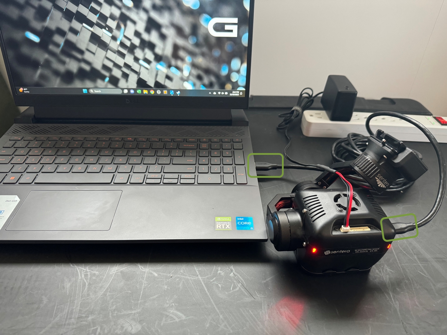
USB-C Cable
Power Supply or Aircraft Battery
Laptop/Computer (Windows & Mac compatible)
External Hard Drive
6X Multispectral Sensor Data Offload Process
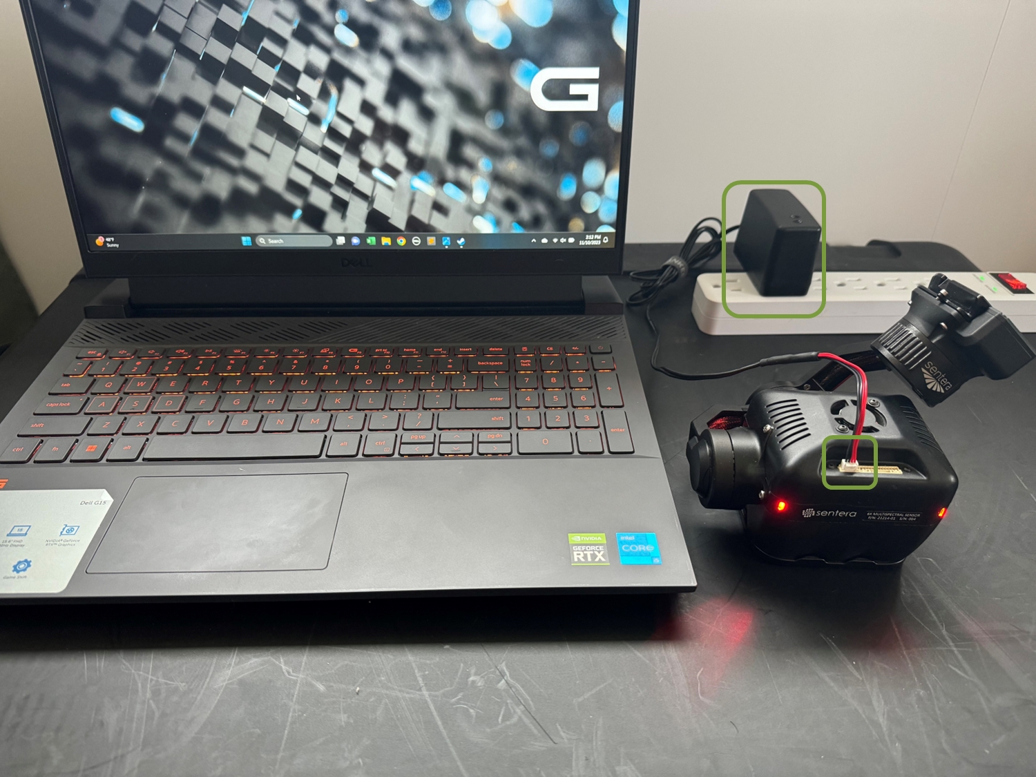
The 6X stores the imagery on an internal solid state hard drive that is not removable from the sensor. Use the process outline below to access the collected data.
Imagery is NOT stored on the micro SD card.
Power the 6X using the AC adapter or keep it attached to the aircraft and turn the aircraft on.
When using the AC power supply, connect the cable to the 6X first, then connect the adapter to the outlet.
For OEM sensor configurations, Ethernet connectivity is also available on the 8-pin J4 connector.
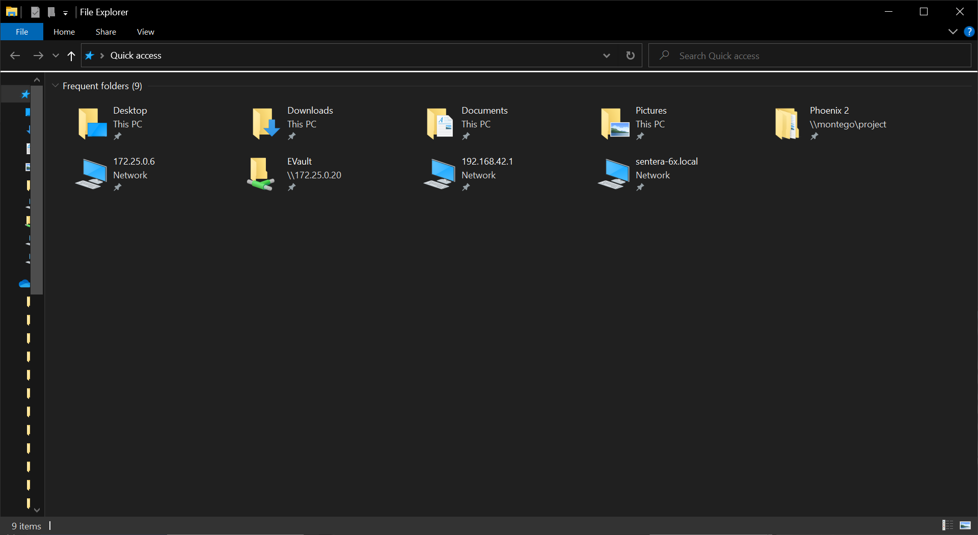
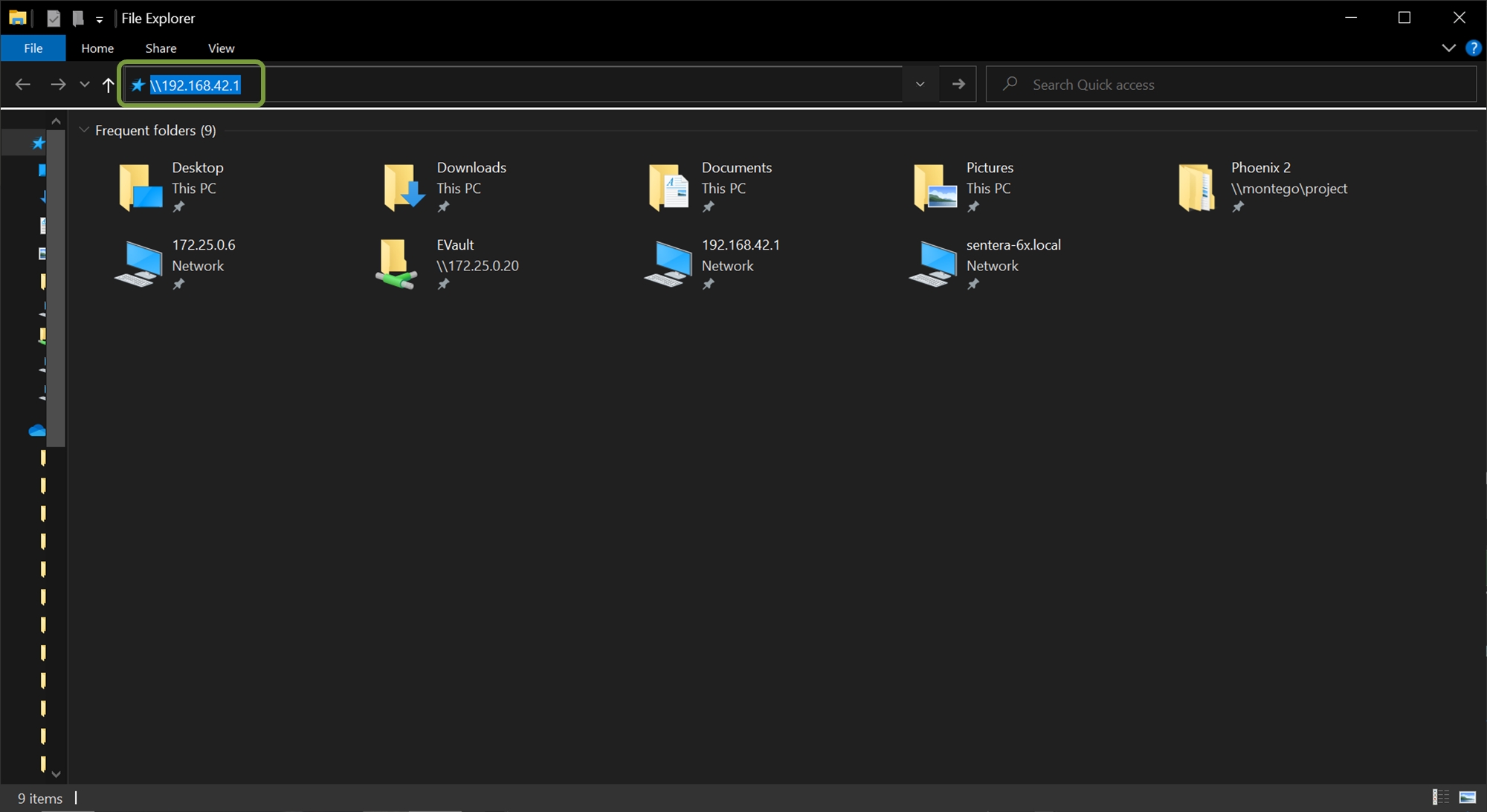
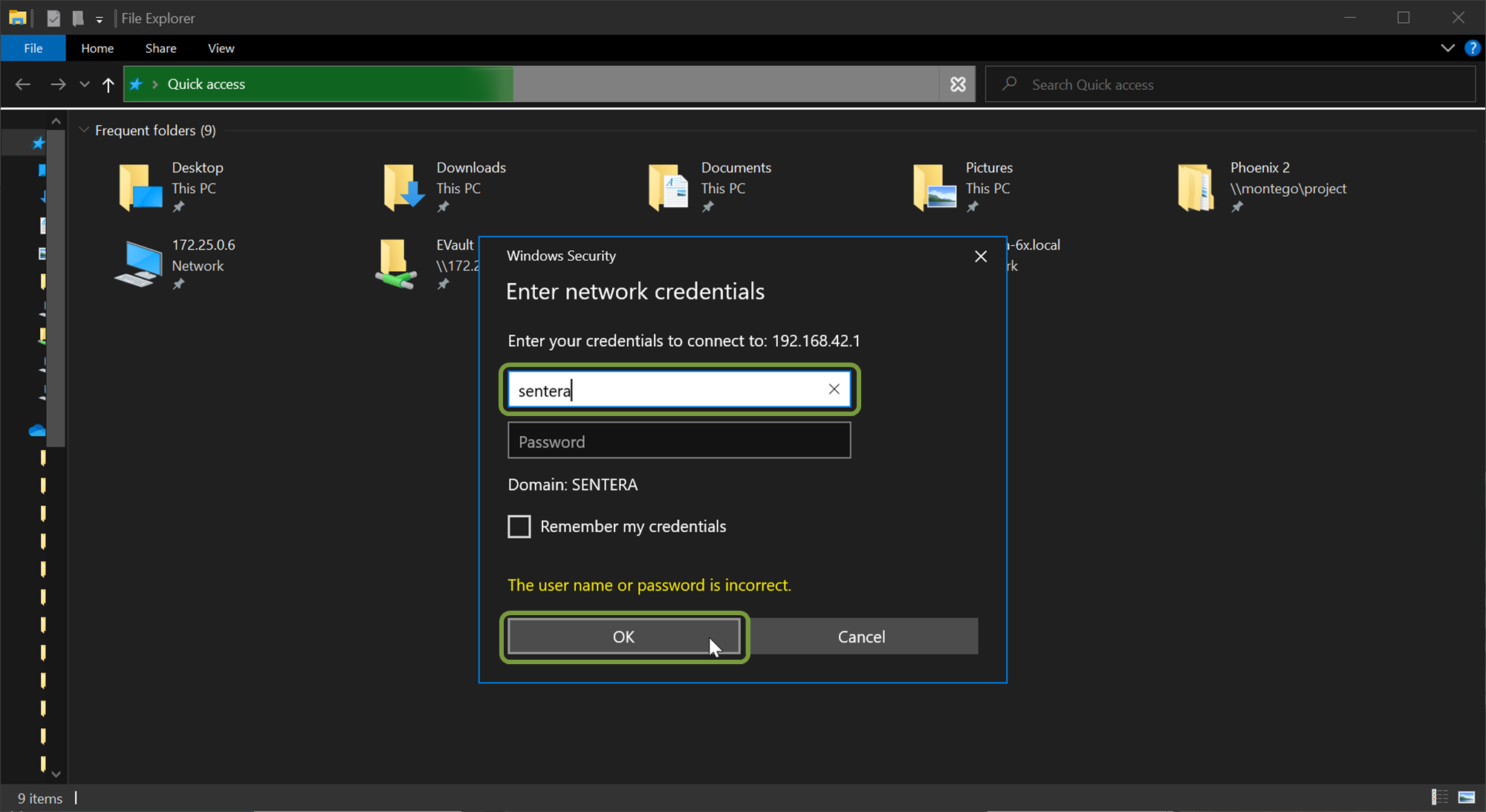
Navigate to the 6X internal storage by typing \\192.168.42.1 into the address bar of the file browser and pressing enter.
The sensor may need a minute to fully boot before it can be accessed via the file browser.
If the 6X can't be connected to after a few minutes try the following: - Turn off/disconnect any Wi-Fi or Ethernet connections that have internet access. - Verify the USB cable being used is the provided cable or one of the listed compatible cables.
Adding this file path to Quick Access can be helpful for repeated use.
Windows will display a network credentials pop-up. The user name is sentera and there is no password. Press OK.
If your user account is controlled by a domain .\sentera may need to be used as the username.
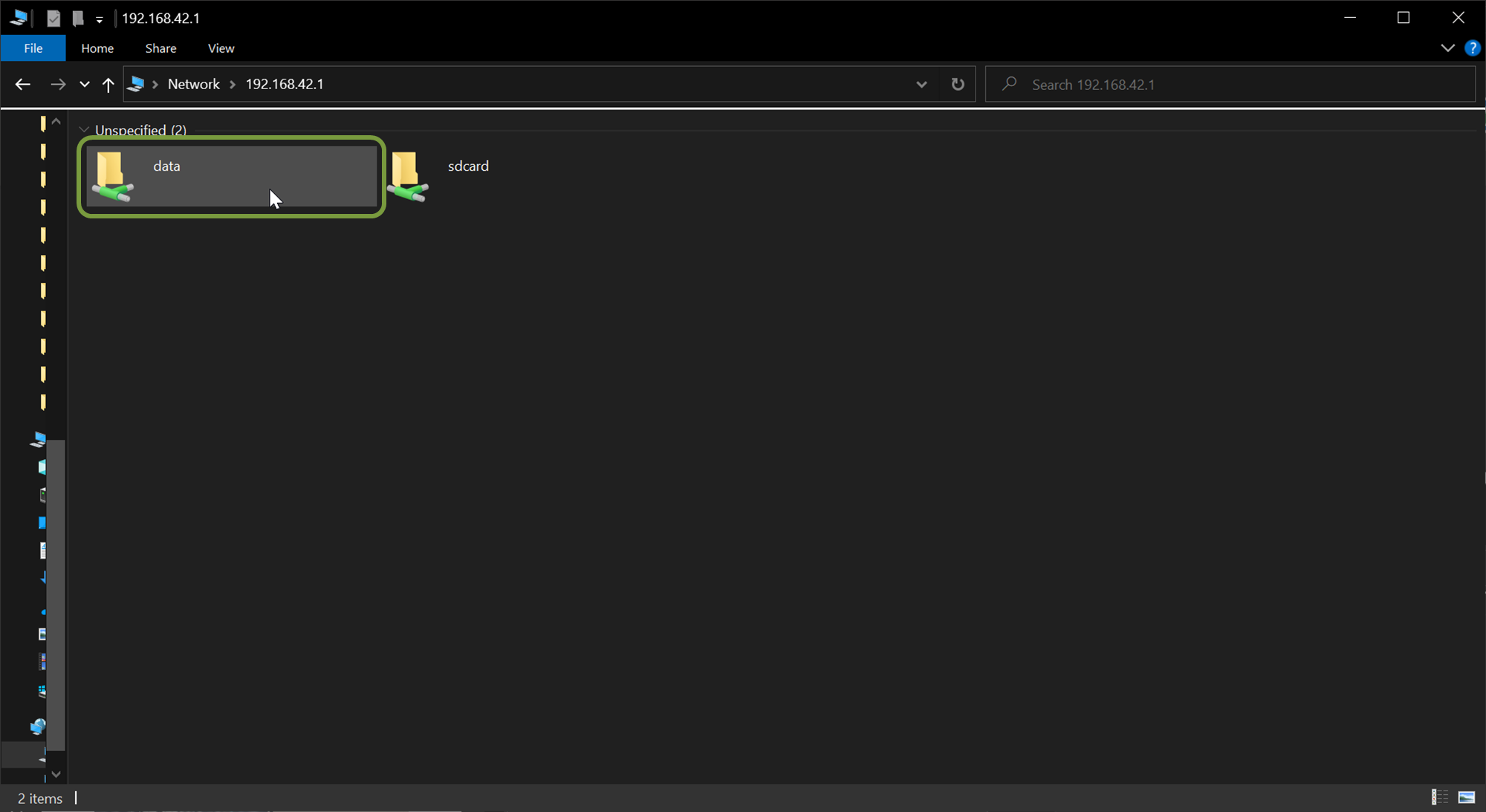
Session folders are the folders where the imagery is stored for each flight.
If the 6X is not power cycled between flights that are intended to be separate (i.e. not a battery swap) all of the photos from both flights will be stored in the same session folder.
6X Multispectral Sensor Data Offload For MacOS
The 6X stores the imagery on an internal solid state hard drive that is not removeable from the sensor. Use the process outline below to access the collected data.
Imagery is NOT stored on the micro SD card.
Power the 6X using the AC adapter or keep it attached to the aircraft and turn the aircraft on.
When using the AC power supply, connect the cable to the 6X first, then connect the adapter to the outlet.
Once the 6X is fully booted it will appear as a network location in the left hand menu of the Finder window.
If the 6X doesn't automatically show up, select the Network option under Locations, as it may appear there the first time the 6X is connected.
If there is a SENTERA-6X-SMB as well, select SENTERA-6X.
If the 6X can be connected to after a few minutes try the following: - Turn off/disconnect any Wi-Fi or Ethernet connections that have internet access. - Verify the USB cable being used is the provided cable or one of the listed compatible cables.
Select the 6X location and then select the data folder.
Session folders are the folders where the imagery is stored for each flight.
If the 6X is not power cycled between flights that are intended to be separate (i.e. not a battery swap) all of the photos from both flights will be stored in the same session folder.
Use the eject button to release the sensor from the OS. This provides the best reliability.
.Tif files from the 6X thermal are recorded in Kelvin*100. As a result, images must be converted to be viewed in Celsius.
To convert thermal pixel values to degrees Celsius:
Raw 6X images off the 6X Thermal will appear solid grey when viewed on most basic image viewers (ex. Windows Photo Viewer). The color scale on a basic photo viewer is set to the range of all possible temperatures that the 6X thermal sensor can record; Black being the coldest and white being the hottest. Relative to the range of possible temperatures, the range of temperatures recorded in a typical 6X image is relatively small. This relatively small range is somewhere in-between the coldest (black) and hotest (white) extremes, causing the image to appear as a nearly constant grey.
Most advanced imagery software will automatically adjust the displayed color range to match the range of temperatures recorded in an image. As a result, raw images viewed using most GIS tools will highlight the temperature differences you'd expect to see in a thermal image.
The image shown below is the same "grey" image seen above, but as it appears in Irfanview. QGIS and other GIS tools will similarly convey the temperature differences in raw imagery.
6X Multispectral Sensor File Structure
The 6X uses an internal SSD to store the captured data. This article will describe the file storage structure.
The 6X file structure is as follows:
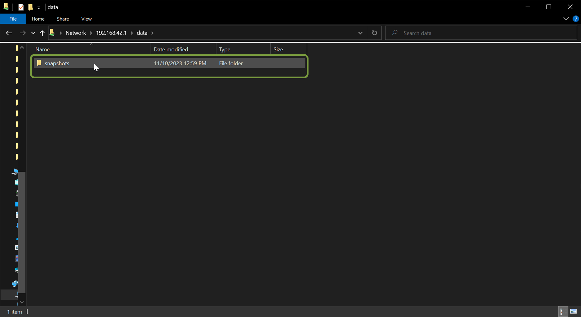
data > snapshots > session folders > data sub-folders (rgb, NIR, Red Edge, etc) > image files
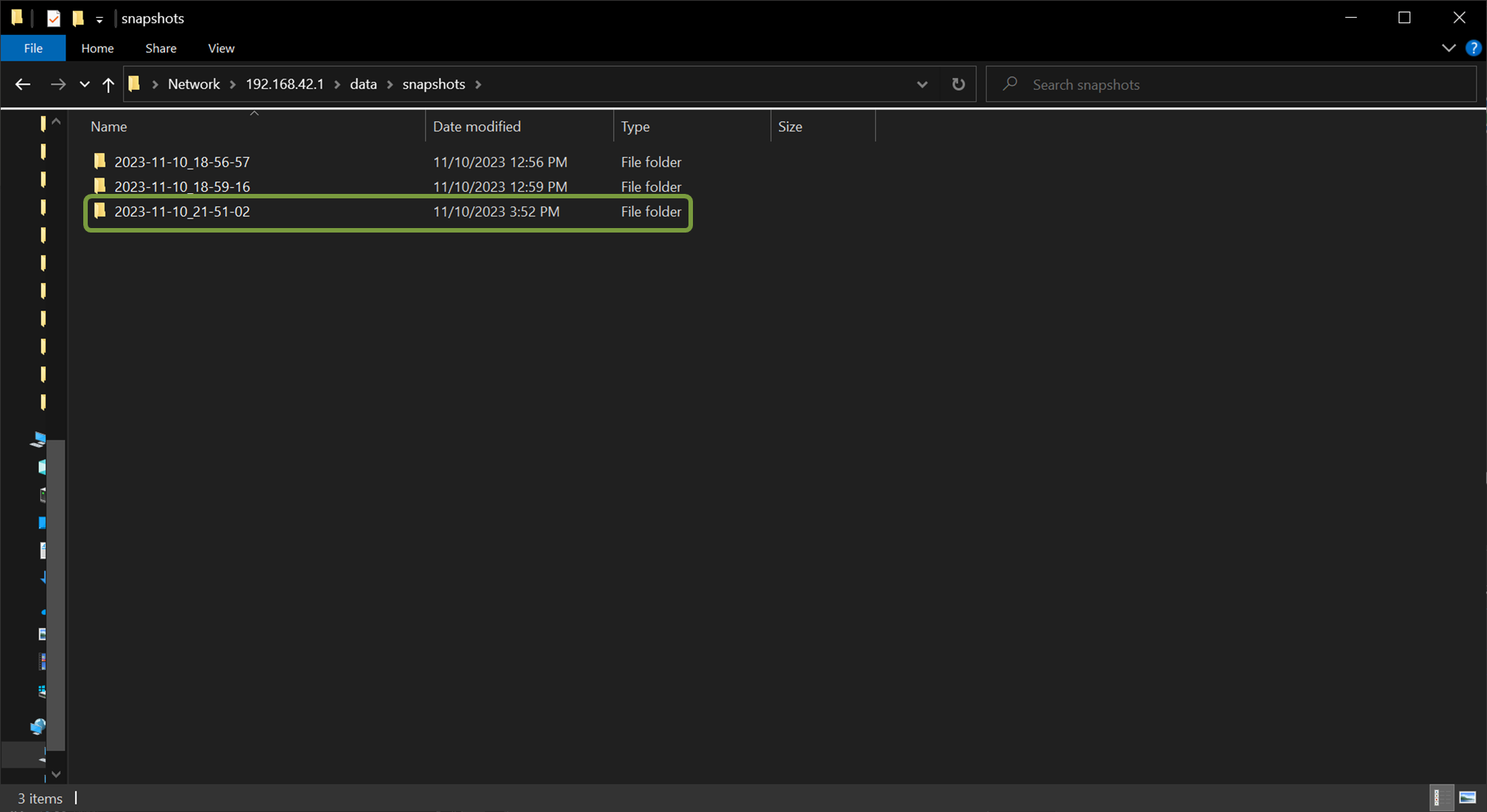
The session folders are labeled as YYYY-MM-DD_HH-MM-SS. Where YYYY-MM-DD is the date that the imagery was collected on, and HH-MM-SS is the UTC time that the session folder created at (when the 6X status lights turned green).
If the 6X is power cycled between flights over a single area, there will be a session folder for each power up and session start of the camera. i.e. the imagery will be split between each folder.
Inside of each session folder there are 6 sub-folders. These sub-folders contain the imagery from each individual lens/channel of the 6X.
The folders are labeled based on the lens filter (Blue, Green, Red, Red Edge, NIR, RGB, etc). The center wavelength and filter width are also displayed.
Inside of each sub-folder the imagery that corresponds to the folder will be found.
| Tag ID | Tag Name | Example Value |
|---|---|---|
| Tag ID | Tag Name | Example Value |
|---|---|---|
| Tag ID | Tag Name | Example Value |
|---|---|---|
| Tag ID | Tag Name | Example Value |
|---|---|---|
| Tag ID | Tag Name | Example Value |
|---|---|---|
| Tag ID | Tag Name | Example Value |
|---|---|---|
| Tag ID | Tag Name | Example Value |
|---|---|---|
| Tag ID | Tag Name | Example Value |
|---|---|---|
| Tag ID | Tag Name | Example Value |
|---|---|---|
| Tag ID | Tag Name | Example Value |
|---|---|---|
| Tag ID | Tag Name | Example Value |
|---|---|---|
| Tag ID | Tag Name | Example Value |
|---|---|---|
0x0100
ImageWidth
1904
0x0101
ImageLength
1428
0x0102
BitsPerSample
12
0x0103
Compression
Uncompressed
0x0106
PhotometricInterpretation
BlackIsZero
0x010A
FillOrder
Normal
0x010F
Make
Sentera
0x0110
Model
21214-00_3.2MP-GS-0001
0x0111
StripOffsets
**variable**
0x0112
Orientation
Horizontal (normal)
0x0115
SamplesPerPixel
1
0x0116
RowsPerStrip
**variable**
0x0117
StripByteCounts
**variable**
0x011A
XResolution
238
0x011B
YResolution
238
0x011C
PlanarConfiguration
Chunky
0x0128
ResolutionUnit
Inches
0x0131
Software
2.0.0-21214
0x0132
ModifyDate
2020:04:10 17:08:21
0xA420
ImageUniqueID
2020-04-10_17-06-34_1
0xA431
SerialNumber
004
0xA434
LensModel
8.0mm-0001-**variable**
0x829A
ExposureTime
1/3759
0x829D
FNumber
1.8
0x8827
ISO
100
0x9000
Exif Version
0230
0x9003
DateTimeOriginal
2019:11:26 20:52:23
0x9004
DateTimeDigitized
2019:11:26 20:52:23
0x9202
Aperture Value
1.8
0x9207
MeteringMode
Average
0x920A
FocalLength
8.0 mm
0x9211
ImageNumber
4
0x9290
SubSecTime
657739
0x9291
SubSecTimeOriginal
657739
0x9292
SubSecTimeDigitized
657739
0xA000
FlashpixVersion
0100
0xA20E
FocalPlaneXResolution
2898.5504
0xA20F
FocalPlaneYResolution
2898.5504
0xA210
FocalPlaneResolutionUnit
cm
0xA402
ExposureMode
Auto
0xA406
SceneCaptureType
Standard
0x0000
GPSVersionID
2.2.0.0
0x0001
GPSLatitudeRef
North
0x0002
GPSLatitude
44.881667
0x0003
GPSLongitudeRef
West
0x0004
GPSLongitude
93.248333
0x0005
GPSAltitudeRef
Above Sea Level
0x0006
GPSAltitude
261.599 m
0x0007
GPSTimeStamp
20:52:23.26451
0x0008
GPSSatellites
13
0x000A
GPSMeasureMode
3-Dimensional Measurement
0x000B
GPSDOP
1.5
0x0012
GPSMapDatum
EGM96
0x001B
GPSProcessingMethod
3D / RTK Float / RTK Fixed
0x001D
GPSDateStamp
2019:11:26
0x001E
GPSDifferential
No Correction / Differential
0x001F
GPSHPositioningError
2.123 m
Camera
AboveGroundAltitude
60.32
Camera
CalibrationPicture
0
Camera
CaptureUUID
1
Camera
FlightUUID
2020-04-10_17-06-34
Camera
GPSXYAccuracy
2.123
Camera
GPSZAccuracy
4.567
Camera
IsNormalized
0
Camera
ModelType
perspective
Camera
PerspectiveDistortion
-0.117, 0.179, -0.045, 0.000, 0.000
Camera
PerspectiveFocalLength
7.800
Camera
PerspectiveFocalLengthUnits
mm
Camera
Pitch
-2.374041
Camera
PrincipalPoint
3.293, 2.406
Camera
RigCameraIndex
0
Camera
RigName
Sentera 6x - Expansion I/O
Camera
RigOffsets
24.765, 0.000, 0.000
Camera
RigRelatives
0.000, 0.000, 0.000
Camera
Roll
0.817388
Camera
Yaw
-105.986984
Camera
BandName
Blue
Camera
BandSensitivity
0.555
Camera
CentralWavelength
475
Camera
SunSensor
15066.786
Camera
WavelengthFWHM
30
Sentera
AboveGroundAltitudeSource
PSDK
Sentera
AlignEnabled
1
Sentera
AutoExposureEnabled
1
Sentera
AutoExposureMaxUs
2000
Sentera
AutoExposureMinUs
400
Sentera
AutoExposureTarget
75
Sentera
AutoExposureUnlockISO
1594
Sentera
CalibrationAGL
60.000
Sentera
CaptureTimestampRosNs
1661288821095056035
Sentera
VignettingEnabled
1
Sentera
AlignMatrix
1.000000*0.000939*92.219727*-0.000939*1.000000*43.974548*0.000000*0.000000*1.000000
Sentera
AlignXYDeg
92.900*43.100*-0.054
Sentera
VignettingCenter
1024.0*768.0
Sentera
VignettingPolynomial
0*0*6.5e-10
0x010F
Make
Sentera
0x0110
Model
21214-00_20MP-ERS-0001
0x011A
XResolution
648
0x011B
YResolution
648
0x0128
ResolutionUnit
Inches
0x0131
Software
2.0.0-21214
0x0132
ModifyDate
2020:04:10 17:08:21
0xA420
ImageUniqueID
2020-04-10_17-06-34_1
0xA431
SerialNumber
004
0xA434
LensModel
7.20mm-0001_0025
0x829A
ExposureTime
1/3759
0x829D
FNumber
2.4
0x8827
PhotographicSensitivity
100
0x9000
Exif Version
0230
0x9003
DateTimeOriginal
2019:11:26 20:52:23
0x9004
DateTimeDigitized
2019:11:26 20:52:23
0x9101
ComponentsConfiguration
Y, Cb, Cr, -
0x9202
Aperture Value
2.4
0x9207
MeteringMode
Average
0x920A
FocalLength
7.2 mm
0x9211
ImageNumber
4
0x9290
SubSecTime
657739
0x9291
SubSecTimeOriginal
657739
0x9292
SubSecTimeDigitized
657739
0xA000
FlashpixVersion
0100
0xA001
ColorSpace
sRGB
0xA002
ExifImageWidth
5184
0xA003
ExifImageHeight
3888
0xA20E
FocalPlaneXResolution
8333.3328
0xA20F
FocalPlaneYResolution
8333.3328
0xA210
FocalPlaneResolutionUnit
cm
0xA402
ExposureMode
Auto
0xA406
SceneCaptureType
Standard
0x0000
GPSVersionID
2.2.0.0
0x0001
GPSLatitudeRef
North
0x0002
GPSLatitude
44.881667
0x0003
GPSLongitudeRef
West
0x0004
GPSLongitude
93.248333
0x0005
GPSAltitudeRef
Above Sea Level
0x0006
GPSAltitude
261.599 m
0x0007
GPSTimeStamp
20:52:23.26451
0x0008
GPSSatellites
13
0x000A
GPSMeasureMode
3-Dimensional Measurement
0x000B
GPSDOP
1.5
0x0012
GPSMapDatum
EGM96
0x001B
GPSProcessingMethod
3D / RTK Fixed / RTK Float
0x001D
GPSDateStamp
2019:11:26
0x001E
GPSDifferential
No Correction
0x001F
GPSHPositioningError
2.123 m
Camera
AboveGroundAltitude
60.32
Camera
CalibrationPicture
0
Camera
CaptureUUID
1
Camera
FlightUUID
2020-04-10_17-06-34
Camera
GPSXYAccuracy
2.123
Camera
GPSZAccuracy
4.567
Camera
IsNormalized
0
Camera
ModelType
perspective
Camera
PerspectiveDistortion
-0.126, 0.197, 0.125, -0.000, -0.000
Camera
PerspectiveFocalLength
7.200
Camera
PerspectiveFocalLengthUnits
mm
Camera
Pitch
-2.374041
Camera
PrincipalPoint
3.110,2.333
Camera
RigCameraIndex
5
Camera
RigName
Sentera 6x - Expansion I/O
Camera
RigOffsets
0.000,-26.670, 0.000
Camera
RigRelatives
0.000, 0.000, 0.000
Camera
Roll
0.817388
Camera
Yaw
-105.986984
Camera
BandName
Red*Green*Blue
Camera
CentralWavelength
620*525*450
Camera
WavelengthFWHM
125*160*130
Sentera
AboveGroundAltitudeSource
PSDK
Sentera
AutoExposureEnabled
1
Sentera
AutoExposureMaxUs
2000
Sentera
AutoExposureMinUs
400
Sentera
AutoExposureTarget
40
Sentera
AutoexposureUnlockISO
1600
Sentera
Brightness
-10.0
Sentera
CalibrationAGL
60.0000
Sentera
CaptureTimestampRosNs
1661288823099520462
Sentera
ColorMatrixEnabled
1
Sentera
Contrast
1.100
Sentera
GammaEnabled
1
Sentera
Saturation
1.050
Sentera
SaturationThreshold
240
Sentera
SharpeningEnabled
1
Sentera
VignettingEnabled
1
Sentera
ColorMatrix
3.449*-0.840*0.011*-0.432*1.529*-0.545*0.047*-0.598*2.229
Sentera
ColorMatrixOffset
0.0*0.0*0.0
Sentera
SaturationColorMatrix
1.350*0.000*0.000*0.000*1.000*0.000*0.000*0.000*1.200
Sentera
SaturationColorMatrixOffsets
0.0*0.0*0.0
Sentera
SharpeningCoefficients
-0.0249000005*-0.0197999999*-0.0131999999*-0.0099999998*-0.0082999999*0.0060999999*0.0126999998*0.0305000003*0.0414999984*1.0487999916
Sentera
VignettingCenter
2592.00*1944.00
Sentera
VignettingPolynomial
0*1.47e-08*0*-3.66e-15*0*5.63e-22
0x0100
ImageWidth
320
0x0101
ImageLength
256
0x0102
BitsPerSample
16
0x0103
Compression
Uncompressed
0x0106
PhotometricInterpretation
BlackIsZero
0x010A
FillOrder
Normal
0x010F
Make
Sentera
0x0110
Model
21216-01_82KP-GS-0001
0x0111
StripOffsets
**variable**
0x0112
Orientation
Horizontal (normal)
0x0115
SamplesPerPixel
1
0x0116
RowsPerStrip
**variable**
0x0117
StripByteCounts
**variable**
0x011A
XResolution
40
0x011B
YResolution
40
0x011C
PlanarConfiguration
Chunky
0x0128
ResolutionUnit
Inches
0x0131
Software
2.0.0-21216
0x0132
ModifyDate
2020:04:10 17:08:21
0xA420
ImageUniqueID
2020-04-10_17-06-34_1
0xA431
SerialNumber
004
0xA434
LensModel
4.5mm-0001-**variable**
0x829A
ExposureTime
1/125
0x829D
FNumber
1.1
0x8827
ISO
100
0x9000
Exif Version
0230
0x9003
DateTimeOriginal
2019:11:26 20:52:23
0x9004
DateTimeDigitized
2019:11:26 20:52:23
0x9202
Aperture Value
1.1
0x9207
MeteringMode
Average
0x920A
FocalLength
4.5 mm
0x9211
ImageNumber
4
0x9290
SubSecTime
657739
0x9291
SubSecTimeOriginal
657739
0x9292
SubSecTimeDigitized
657739
0xA000
FlashpixVersion
0100
0xA20E
FocalPlaneXResolution
8333.3328
0xA20F
FocalPlaneYResolution
8333.3328
0xA210
FocalPlaneResolutionUnit
cm
0xA402
ExposureMode
Auto
0xA406
SceneCaptureType
Standard
0x0000
GPSVersionID
2.2.0.0
0x0001
GPSLatitudeRef
North
0x0002
GPSLatitude
44.881667
0x0003
GPSLongitudeRef
West
0x0004
GPSLongitude
93.248333
0x0005
GPSAltitudeRef
Above Sea Level
0x0006
GPSAltitude
261.599 m
0x0007
GPSTimeStamp
20:52:23.26451
0x0008
GPSSatellites
13
0x000A
GPSMeasureMode
3-Dimensional Measurement
0x000B
GPSDOP
1.5
0x0012
GPSMapDatum
EGM96
0x001B
GPSProcessingMethod
3D / RTK Float / RTK Fixed
0x001D
GPSDateStamp
2019:11:26
0x001E
GPSDifferential
No Correction / Differential
0x001F
GPSHPositioningError
2.123 m
Camera
AboveGroundAltitude
60.32
Camera
CalibrationPicture
0
Camera
CaptureUUID
1
Camera
FlightUUID
2020-04-10_17-06-34
Camera
GPSXYAccuracy
2.123
Camera
GPSZAccuracy
4.567
Camera
IsNormalized
1
Camera
ModelType
perspective
Camera
PerspectiveDistortion
0.000, 0.000, 0.000, 0.000, 0.000
Camera
PerspectiveFocalLength
4.500
Camera
PerspectiveFocalLengthUnits
mm
Camera
Pitch
-2.374041
Camera
PrincipalPoint
0.192, 0.154
Camera
RigCameraIndex
4
Camera
RigName
Sentera 6x – Expansion I/O - Boson
Camera
RigOffsets
-24.765, 0.000, 0.000
Camera
RigRelatives
0.000, 0.000, 0.000
Camera
Roll
0.817388
Camera
Yaw
-105.986984
Camera
BandName
LWIR
Camera
BandSensitivity
1.000
Camera
CentralWavelength
11000
Camera
WavelengthFWHM
6000
Sentera
AboveGroundAltitudeSource
PSDK
Sentera
CalibrationAGL
60.000
Sentera
BosonCameraSerialNumber
129751
Sentera
BosonCameraTemp
40.85
Sentera
BosonCoreTemp
48.96
Sentera
BosonFFCState
3
Sentera
BosonFrameCounter
25114
Sentera
BosonOvertempCounter
0
Sentera
BosonSensorSerialNumber
3232567
Sentera
BosonSoftwareRevision
3.0.25868
Sentera
BosonTelemetryRevision
2
Sentera
CaptureTimestampRosNs
1661290645360142086